
Introduction
MapMagic is a software package for producing refined geodata products for locations in Denmark. The products are optimized to be used as the primary data basis for the production of high-detail maps such as orienteering maps. While the raw data needed are freely available, it requires a background in computer science and geoinformatics in order to produce the desired products.
Purpose
The purpose of MapMagic is to help raising the quality of Danish orienteering maps by providing easy access of free high-quality data products for mappers who may not have a background in computer science.
Data Basis
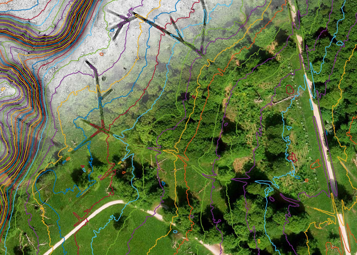
MapMagic uses freely available geodata provided by the Danish Agency for Data Supply and Efficiency through the online portal Kortforsyningen. The primary dataset used is Punktsky which the basis of the Danish Height Model (DHM). Punktsky is a 3-dimensional dataset that consists of georeferenced and classified LIDAR points. The average point density is 4.5 points per square meter. The accuracy is about 5 cm in the vertical dimension and 15 cm in the horizontal dimension.
About
MapMagic is developed and maintained by Ulrik Nielsen who has a background in radar signal processing and data analysis.
Contact
MapMagic is a software package for producing refined geodata products for locations in Denmark. The products are optimized to be used as the primary data basis for the production of high-detail maps such as orienteering maps. While the raw data needed are freely available, it requires a background in computer science and geoinformatics in order to produce the desired products.
Purpose
The purpose of MapMagic is to help raising the quality of Danish orienteering maps by providing easy access of free high-quality data products for mappers who may not have a background in computer science.
Data Basis
MapMagic uses freely available geodata provided by the Danish Agency for Data Supply and Efficiency through the online portal Kortforsyningen. The primary dataset used is Punktsky which the basis of the Danish Height Model (DHM). Punktsky is a 3-dimensional dataset that consists of georeferenced and classified LIDAR points. The average point density is 4.5 points per square meter. The accuracy is about 5 cm in the vertical dimension and 15 cm in the horizontal dimension.
About
MapMagic is developed and maintained by Ulrik Nielsen who has a background in radar signal processing and data analysis.
Contact
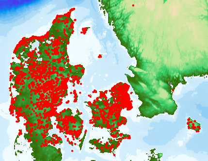
Map showing MapMagic orders to date